The Building of the Canal
|
The building of the Oxford Canal Navigation, as it was then known, was approved by Act of Parliament in 1769. Work commenced in 1770 and the ninety-one mile route was finally opened from Coventry to Oxford on 1st January 1790. The original engineer was James Brindley (on a salary of £200 per year!), but he had died in 1772, when the canal had only been dug as far south as Brinklow. He was replaced by his brother-in-law Samuel Simcock.
The canal as built followed a tortuous route along the 300ft contour line from Longford in Coventry as far as Hillmorton Locks; it was said that a boatman could travel for a whole day and still remain within the sound of Brinklow’s church bells. The same applied to Braunston church as well! There is no certain explanation for this winding line, because Brindley had not clung quite so tightly to contours in earlier canals but it is likely that he was forced to choose such a route for economy – embankments and cuttings are costly to build and maintain. The canal was showing a profit before the route was finished, even though it was still an isolated canal. In 1793 the Coventry Canal and Grand Junction Canal were completed and the boom years of canal mania had arrived. |
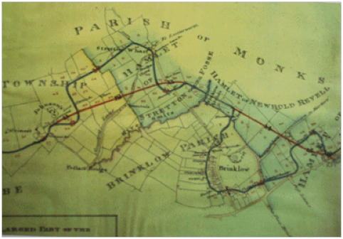
The Old Canal around Brinklow
|
The old line crossed the Fosse Way three times; just south of the boatyard entrance there is still a depression in the road, again just past the farm before Ell Lane and near the Post Office. Some of the buildings reflect the existence of the canal, and the now demolished Candle Factory was canal side.
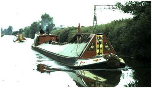
By 1793 Stretton Wharf was the fifth most important coal wharf on the Oxford Canal. There was also a mill there; the building (now used by Brinklow Boats Services) still stands in the industrial estate and can be seen from the road where the Fosse Way branches away from the B4027. |
|
The “Brinklow Arches”, just south of bridge 30 where the canal crosses the Smite Brook, was Brindley’s largest aqueduct in terms of height combined with length. There were twelve arches, each with a 22ft span, the highest being 31ft 6ins. The whole structure was 300ft long, connected to a 600ft embankment at one end and 400ft at the other. This would have been an engineering marvel when built but it is only possible to see one complete arch today, the one over the Smite Brook. Beside it is the top of a second arch. When the canal was straightened, one side of the aqueduct was filled in order to widen the channel, which used to be wide enough for only one boat. The other side has gradually been filled in with dredgings.
|
The Straightening of the Oxford Canal
|
By the beginning of the 1820s the Oxford Canal was the M1 of its day and the principle artery for moving coal and almost all other goods from Coventry and points north to London, generating good profits for the shareholders. However, its winding route between was deeply unpopular with canal carriers. Eventually there was such dissatisfaction that a new, more direct canal was proposed. Stung into action by the threat of a serious competitor the Oxford Canal Company resolved to shorten the line of the canal between Hawkesbury and Braunston. Sir Marc Brunel and Charles Vignoles made the survey, William Cubitt was appointed engineer. Work started in 1829 and the new line was opened on 13th February 1834 at a cost of £167,172. The route was shortened by almost eleven miles, nearly half the original length!
|
|
The new sections, easily identifiable by the way they are constructed, cut arrow straight across the terrain on a series of embankments and cuttings. The canal south from Napton to Oxford was never modernised as most traffic to London left the Oxford canal at Braunston to take the Grand Junction Canal to London in preference to the longer route via Oxford and the River Thames.
However the new, direct, route bypassed many of the busy wharves, such as the one at Stretton, so sections of the old line of the canal (called “arms”) were retained to serve the various wharves, the towing path being carried over them where necessary by graceful cast iron bridges made by the Horseley Iron Works at Tipton. These are regarded as some of earliest examples of mass production and one can be seen just past the Brinklow Arches over the arm to Brinklow . The rest of the old route where no longer required was sold, normally back to the local farmers. Much as been filled in, but even after almost 200 years plenty of sections remain if you know where to look. |
|
The Stretton Arm, opposite the boatyard, was one such part of the old canal which used to run straight across the existing canal and underneath the shop at the boatyard. The wharf at Brinklow was also retained, crossed by a Horseley Ironworks bridge and was mentioned in an amusing article in the Rugby Advertiser of the 18th July 1857 when an “aquatic party, per canal, from Coventry” (complete with brass band) finished their evening thus: “as the sun sank in the far West, the happy couples wended their way the “Fair Rosamund”, which was moored off Brinklow Bay”. Clearly the local equivalent to Wigan pier!
|
Stretton Stop
|
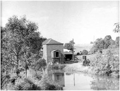
The area known as Stretton Stop came into being with the straightening of the canal in the 1830s. The “stop” itself is the narrow part of the canal by the cottage. It contained a pair of gates used to hold back (stop) the flow of water from the canal in the event of a breach of one of the large embankments. The gates have now been removed but the recesses for them can still be seen. The other use of the stop, however, was to gauge the amount of cargo on board. Carrying boats were charged a toll to use the canal based upon the tonnage carried. Each boat used on the canal would be “gauged” by the Oxford Canal Company in a special dock at Hillmorton. The boat would be gradually loaded with weights and its freeboard (i.e. from the gunwale to the water) measured as it was loaded. A copy of this record would have been kept at in the toll office at Stretton and used to calculate the cargo weight, and thus the toll due.
The front room of the house was the toll office. The large bay window gave the toll clerk an excellent view of approaching traffic. The cellars underneath the cottage have an interested vaulted ceiling; the front cellar was used for storing coal, the rear one as a scullery. The brick part of the shop was originally a stable and stores – narrowboats were predominantly horse drawn until the 1920s. |
Recent History
|
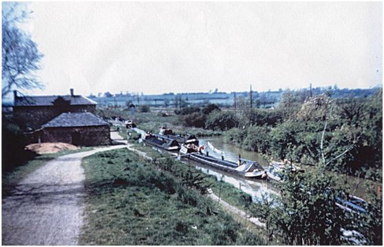
Commercial carrying of goods by canal declined dramatically throughout the 1960s with last carrying companies struggling on until 1970. The last toll keeper and his family moved out in the early 1950’s and the site lay derelict for some years until Maid Line took it over and set up a hire fleet in 1962. This is when the paint shed and slipway was built At that time there were very few hire boat companies on the canals and their fleet of small plywood cruisers were pioneers – but a far cry form the well furnished steel narrowboats of today!
The last regular long distance traffic was operated by Blue Line Limited, which was coal loaded at Atherstone, passing through Stretton Stop on the way to the Kearley and Tonge jam factory at Southall in London. The future looked bleak for the canals at this time but the British Waterways Board, founded in 1965, had been tasked with developing and maintaining certain canals, including the Oxford for leisure purposes and slowly the numbers of people using the canals for pleasure boating began to rise. In November 1963 there was a serious breach of the canal a few miles north at Ansty where a 30ft high embankment gave way and washed 10,000 tons of clay and sand onto adjoining land. Fortunately the problem was spotted by a farmer who, out for an early morning walk with his dog, noticed one of his fields was now under water. He raised the alarm and quick action by British Waterways staff prevented the breach becoming a serious catastrophe that could have closed the Oxford Canal for a long time. Repairs were completed quickly and the canal re-opened for traffic. Shortly afterwards there was another less serious breach at Newbold. |
|
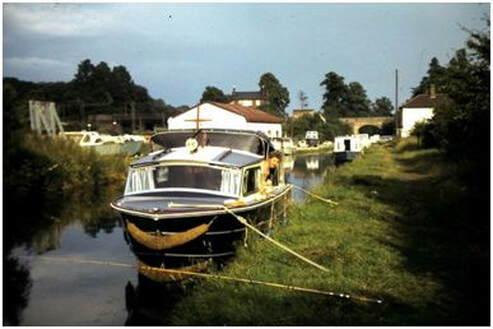
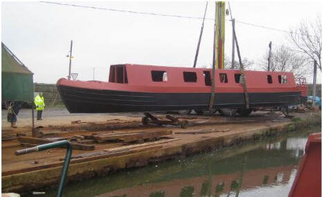
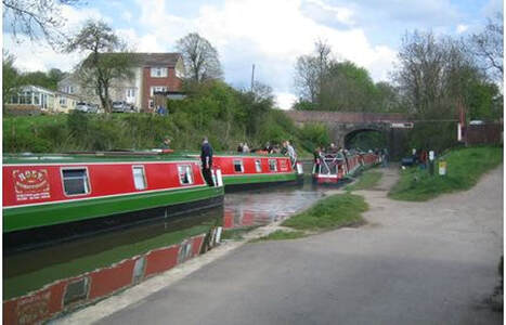
The change of ownership to Rose Narrowboats Ltd saw the introduction of the first narrowboat style hire boats in the early 1970’s. Throughout the 1980s and 1990s canals gained in popularity as a leisure resource and many improvements were made to the condition of canal and towing path. In 1998, the remaining length of the Stretton Arm was made navigable for the first time in over 50 years and a new boatyard opened on the old Stretton Wharf specialising in restoration of historic boats and building high quality replica hulls.
|
|
Leisure usage of the canal system has continued to expand rapidly into the 21st Century and in 2012 the British Waterways Board was re-organised into a new charity, the Canal & River Trust which is dedicated to preserving and maintaining the canal and navigable river network for the benefit of all. The Oxford Canal through Brinklow has now been open for over 240 years and Rose Narrowboats Ltd is proud to have played its part in that history since 1972.
|